Tuesday, September 28, 2010
It was good while it lasted
My blogging public will, alas, never get to see my stunning pictures of St. Michael's Mount (not to be confused with Mont St. Michel, although it was owned by the worldly monks who lived there for a few hundred years after the Norman conquest). After taking pictures of the Mount, I walked to Porthleven, and found that my luggage had been stolen from the hotel where my luggage transfer service had delivered it. With only the clothes on my back, and a backpack luckily containing my cameras and electronic devices -- but no chargers -- the only sensible option seemed to be beat a retreat back to Washington. Which left me disappointed to have my walk so rudely ended, and feeling somewhat wimpy for not hiking on with whatever meager supplies of clothing and supplies I could find in a small English fishing village. At least the hotel manager, a really nice guy, drove me to the railroad station 12 miles up the road in Penzance.
Wednesday, September 22, 2010
It sounded like a good idea in 1821
A misty day with just enough rain to break out the Goretex. But not a bad day for walking, but not much of a day for photography. Raining and blowing when I rounded Land’s End – the westernmost point in England, or at least Cornwall – so I had to take a picture looking back when the rain tapered to a soft drizzle. Even so, you can barely see Longships Lighthouse a mile off Land’s End.

After that, a standard day marching up headlands and down into valleys. Lots of interesting rocks, but not much else.
Except the markers at Gwennap Head to help mariners avoid Runnel Stone. The theory, when these cones were installed in 1821, was that if the black and white cone is completely hidden by the red cone, you’re on top of the reef. Which you probably know, from the crunching sound and the water rushing in.

That may be why no less than 30 steamers were wrecked on Runnel Rock between 1880 and 1923. Today, there is a buoy with lights on top of the reef, which also sounds a moaning wail like “the hoot of an unhappy owl,” the local guidebook says. In fairness to the 19th Century, it seems to have been a difficult feat to position a buoy atop Runnel Stone in a stable way. I’m not enough of a buoy scholar to know why.
Tuesday, September 21, 2010
Aye, must be a rough sea up there…
In addition to all the other reasons I wouldn’t want to be a miner, the Cornish mines added the twist of extending their horizontal shafts – the ones spreading out from the central vertical shafts – under the sea. So the miners could hear boulders on the ocean floor above rolling back and forth with the tide. I’d find that quite disquieting.
The last tin mine in this area closed in 1990, and little as we might want to be miners, the retired miners who man the reconstructed engine house of the old Levant mine seem quite nostalgic for the good old days. I asked one how to find my way up to the Geevor Mine, the mine closed in 1990, now operated as a tourist site. He walked me 100 yards up the small path that functions as a shortcut, and told me to follow this to Maggies Lane (“Of course, you won’t know it’s Maggies Lane, but it is”), and then up the lane to Geevor.
The Levant mine engine house has a remarkable two-stroke steam engine which operated from 1840 to 1930, hauling ore up to the surface and powering the cage which moved miners up and down. Amazingly enough, the engine still works today:

The Pendeen lighthouse appears in the background. One of the consequences of having high headlands is that it allows short, squatty lighthouses. This one certainly lacks the imposing presence of, say, Diamond Head on the outer banks of North Carolina. The Pendeen lighthouse does, however, prove the earth is round. The keeper at the next lighthouse up the coast could see the Pendeen light at low tide, but not at high tide. The earth’s curvature between the two was just enough for the rising tide to cut off the view of the Pendeen light.
The Crowns Shaft engine houses slightly down the coast were built in a seemingly impossible postion on a rocky outcrop. It is possible to walk down to them – I didn’t – but its hard to see carrying building materials and steam engines down the path, or hoisting them up from the rocky cove below.

As what I almost promise will be the last mine picture, I can’t resist putting in a picture of the Botallack engine house, a few hundred yards further down the coast.

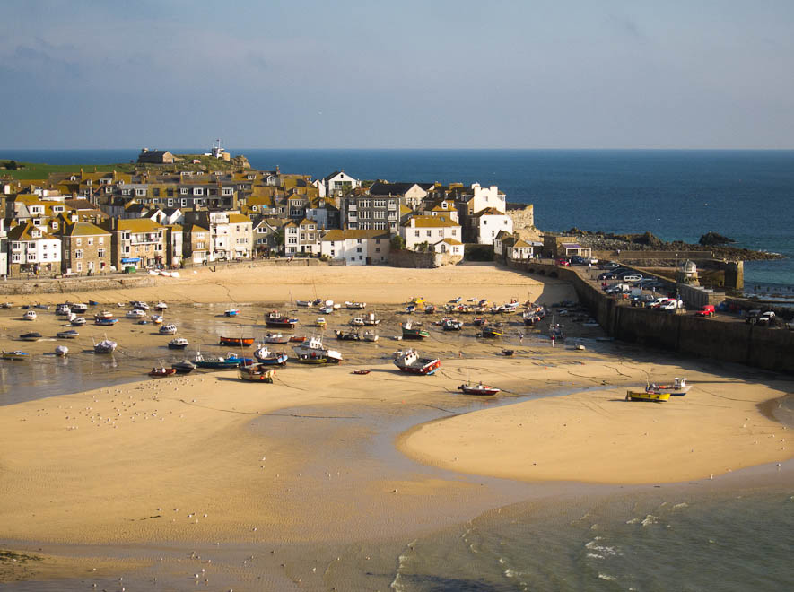
Finally, speaking of tides, I had a chance to take another picture of the harbor of St. Ives the morning after the one in the post below.

The first picture was taken roughly at high tide. This second picture, with boats lying on the harbor’s sand bottom, was taken when the tide was about half out.
The last tin mine in this area closed in 1990, and little as we might want to be miners, the retired miners who man the reconstructed engine house of the old Levant mine seem quite nostalgic for the good old days. I asked one how to find my way up to the Geevor Mine, the mine closed in 1990, now operated as a tourist site. He walked me 100 yards up the small path that functions as a shortcut, and told me to follow this to Maggies Lane (“Of course, you won’t know it’s Maggies Lane, but it is”), and then up the lane to Geevor.
The Levant mine engine house has a remarkable two-stroke steam engine which operated from 1840 to 1930, hauling ore up to the surface and powering the cage which moved miners up and down. Amazingly enough, the engine still works today:

The Pendeen lighthouse appears in the background. One of the consequences of having high headlands is that it allows short, squatty lighthouses. This one certainly lacks the imposing presence of, say, Diamond Head on the outer banks of North Carolina. The Pendeen lighthouse does, however, prove the earth is round. The keeper at the next lighthouse up the coast could see the Pendeen light at low tide, but not at high tide. The earth’s curvature between the two was just enough for the rising tide to cut off the view of the Pendeen light.
The Crowns Shaft engine houses slightly down the coast were built in a seemingly impossible postion on a rocky outcrop. It is possible to walk down to them – I didn’t – but its hard to see carrying building materials and steam engines down the path, or hoisting them up from the rocky cove below.

As what I almost promise will be the last mine picture, I can’t resist putting in a picture of the Botallack engine house, a few hundred yards further down the coast.

Finally, speaking of tides, I had a chance to take another picture of the harbor of St. Ives the morning after the one in the post below.
The first picture was taken roughly at high tide. This second picture, with boats lying on the harbor’s sand bottom, was taken when the tide was about half out.
Monday, September 20, 2010
How do fire trucks find them?
I spent an hour today searching for the house of two acquaintances who tell us they live “right on the Coast Path,” in a house called Dabbers Den on Porthminster Point. That may have been a figure of speech, since there’s no Dabbers Den on the Path as is winds around Porthminster Point, or anywhere else on the Point that I could find (it’s a small neighborhood, so looking around was not that big an exercise).
But, as elsewhere in England, all the houses are lovingly named – Pleasant Cove, Atlantic View, The Haven, etc. The houses aren’t numbered, however, and only about half the streets have name signs, and those usually only at one end of what may be a street of several blocks.
Which make me ask: How to fire trucks find them, if the only address is “Dabbers Den in Porthminster Point”? In the U.S., fire departments go bonkers if people put their street numbers in script, since they say that makes it hard to find “Forty Nine Ought Six” Tilden Street compared with a sensible, crisp “4906,” and reasonably so. But are English firefighters like London taxicab drivers, required to memorize where every Dabbers Den and Atlantic View is within a 10-mile radius? Seems improbable.
Apart from mulling this question, I had a quiet, unexciting day. Walked around the Hayle Estuary, which let me take another estuary picture, this time to show that boat owners need to plan ahead, since at low tide their boats are very high and dry.

At Porthminster Point, I took a picture of the lighthouse in the bay. Lucky people to have the view. I don’t think it’s Virginia Woolf’s lighthouse of To the Lighthouse, although that is somewhere along here.

Finally, a picture of St. Ives harbor from my hotel window. A pretty seaside town with a supposed tradition of being an artist’s colony. That must have some truth, since there is a branch of the Tate Museum here. But the 47 art galleries in the tourist section of town are no great shakes.

P.S. While posting this in my hotel sitting area overlooking the harbor (since wi-fi doesn't reach my room), the hotel owner popped in to tell me that General Omar Bradley had his headquarters in this building in the run-up to D-Day. (We agreed that American generals certainly knew how to pick out their GHQ's.) And the church outside the window is called the "New Church," because it was consecrated in 1487.
Sunday, September 19, 2010
The Mines of Cornwall
Cornwall looks hopelessly pastoral today. Sheep, dairy cows, and endless hedge-defined pastures. In the 19th Century, quite another story. Cornwall was where the metals action was. Tin and copper, as usual found with smaller concentrations of tungsten, manganese, etc. were major products, with the coastal area peppered with small shafts and mine openings everywhere. Given the high costs of transporting ores, small scale smelters to extract metals from the ores were everywhere.
Today, the old smelters and mine houses are among the most popular targets for photography along the Coast Path. I have no pride, I joined the crowd today.


Today, the old smelters and mine houses are among the most popular targets for photography along the Coast Path. I have no pride, I joined the crowd today.


The abandoned mine shafts, on the other hand, are among the greatest dangers along the this part of the coast. They undoubtedly cause more injuries than the occasional walker tumbling off the Path and into the sea. Where landowners have been conscientious, the shaft openings are covered with conical metal hats.

But, overall, probably one out of ten abandoned shafts is marked, let alone covered. For the rest, the Coast Path relies on signs with stern warnings not to stray off the path. Which adds a certain edginess to efforts to tramp through the gorse in search of just the perfect place to take a picture.
Saturday, September 18, 2010
Within the Tides
(with apologies to Joseph Conrad, and his 1916 short story collection of the same name) The tidal range along the Cornwall coast seems a lot bigger than for our Midatlantic Coast. I haven't stayed in any one place long enough to see just how much the tide rises and falls, but it does affect your options here and there. For example, walking out of Newquay this morning I potentially had four different ways I might need to cross the Gannel River estuary, affecting the lengh of my day's trek by as much as six miles. By good fortune, I was leaving near low tide, so I could not only use the Fern Pit Cafe alternative -- the shortest -- but I could also use the Cafe's low-tide footbridge, rather than paying one pound to use their ferry (in the foreground), and not have to walk inland to use the official Coast Path footbridge, or even further (if the tide were full and the Cafe were closed) to use the highway bridge.


At the end of my day, approaching Perrenporth, I could walk all the way down Perren Beach to town if I could reach Cottys Point before the tide put the beach under water there. Otherwise, I'd have to climb still another high headland, and back down the other side, to reach town. I barely made it.

The teenagers behind me didn't quite make it, and found the need to wade through the incoming tide hilarious. One lad portaged his and his girlfriend's shoes on a boogie board on a tether, while the other guy told the girls that just to be on the safe side they should probably take their pants off.

In between the River Gannel and Cottys Point, I found the youngest surfing class yet on Holywell Beach. There are surfing classes on every beach, but they're generally filled with teenage girls. I guess guys think it's beneath their dignity to take formal classes, and girls think surfing is where the boys are.

But this co-educational class was getting an enthusiastic early start on the favorite local sport, under the watchful supervision of a number of instructors and, off camera, a gaggle of mother hens.
Friday, September 17, 2010
Take This, Big Sur
Today's starring attraction was the Bedruthian Steps, a series of jagged rocks rising out off the surf on a sandy beach beneath a 200-foot high headland. The beach is reached down a vertiginous series of near vertical steps (but with handrails, unlike less celebrated steps on the Path). The Steps (the rocks) are owned by the "Caranton Estate," the property of some local nobility; the steps (way down) were originally built as a Victorian tourist attraction after the railroad reached the area in 1875.
In any case, the Bedruthian Steps are the first thing I've seen on the Cornwall Coast that can give the Big Sur a match for photo opportunities. They are quite entrancing, and I could prowl around the cove for days taking pictures in different ways in different light. But these will have to do:


In any case, the Bedruthian Steps are the first thing I've seen on the Cornwall Coast that can give the Big Sur a match for photo opportunities. They are quite entrancing, and I could prowl around the cove for days taking pictures in different ways in different light. But these will have to do:


After I reluctantly (and slowly, and carefully) climbed the steps back to the Coast Path, the rest of the march to Newquay was a series of Cornish surfing beaches. Once again, the surfers were out waiting vainly for ridable waves. But what waves there were came rolling in with a stately regularity.


These wonderful wave sets must be the product of a long, gently-sloping beach, which in turn is the product of the fact that Cornish beaches are all in coves, closed in by headlands on either end and usually with a small stream entering from a narrow valley in the center. As a consequence, the sand stays in one place, and over the years builds up an even, gently deepening bottom. This is in sharp contrast, of course, to the long, unbroken beaches along much of the Eastern United States, which allow the sand to be carried away down (or up) the coast in storms. Lucky devils, these Cornish surfers. Presumably, there are more respectable waves at other times, hopefully when the weather is not too much worse than the last few days (temperatures in the range of 60 degrees, with water temperatures apparently in the mid-50's, according to one surfer).
Thursday, September 16, 2010
A Stroll from Padstow to Porthcothan
Easy day today. Not as flat as a billiard table, but close to it by Coast Path standards. The weather was great, too. Sunny, warm enough to bring English families to the beach (that is, almost 60 degrees, and winds a little less than 20 knots).
Unfortunately, because of the relatively tranquil weather, I didn't get to see the Spirit of Padstow launched down the rails from its Batcave. Here's what the RNLI (ne Royal National Lifeboat Institution) lifeboat station looked like today. Beneath that is what it would look like with the 52-foot, 30-ton Spirit of Padstow being launched from the Batcave to rescue a yacht, or even a lowly fishing boat in distress.


I was, needless to say, bitterly disappointed. But I consoled myself by taking pictures of the meager waves on offer today roiling against the rocks that sit out in the water along this section of the coast. Although it's just about impossible to produce a decent black-and-white picture on a laptop screen (no color control, appearance changes radically with a small shift in up-and-down viewing angle), I tried my hand with one after I reached Porthcothan.

Finally, I went back to look at the pictures I took several days ago of the dwarf sessile oaks that uniquely grow in small forest preserve near Dizzard, north of Crackington Haven.


Compared with the standard sessile oak, Quercus petraea, which grows from 60 to over 140 feet in height, these twisted, stunted salt-tolerant oaks which survive on the wind-driven coastal slope rising from the ocean at Dizzard are 30 feet high at most, and often smaller. It looks like a forest for witches and goblins.
Wednesday, September 15, 2010
Country Graveyards
The title of this post was going to be Surfer Dudes; the reason for the the actual title will become clear in time. As for the Surfer Dudes, Cornwall became besotted with surfing when neophene wetsuits became available in the 1980s. Any faint suggestion of sand is now ringed with surf shops selling all the usual equipment, parking lots filled with wanna-be woodies with board racks on the roof, and so forth.

Alas, for even an East Coast American, the actual waves seem to be pretty minimal, and the surfers more occupied with milling about in the water than actually surfing. Maybe it was an off-day for this picture, taken in Polzeath.
As a passing aside, for readers like me who were lucky enough to spend days on windy American beaches in the 1970's, and who have been puzzled by the disappearance of those canvas windshields that were used then to -- unsuccessfully -- protect us from blowing sand and chill breezes, the answer is apparently that they are all being exported to England so that families with young children there can go to the beach and be miserable in the same way we were in the 1970's.

After this tour of Cornish surfing and family beaches, I moved on to more cultural pursuits. The attraction advertised by my guidebooks was the Sunken Church, specifically the 13th Century Church of St. Enodoc. The story is that the church has gradually sunk into the sand, leaving it still in service but half-disappeared. The only approach to the church from my surfing beach, and indeed from any other direction as far as I could tell, appears to be across the fairways of the St. Enodoc Golf Club, which aside from exposing the walker to the ire of club members out for a quick 18 holes on a workday -- golfers, especially country club golfers, are a territorial lot -- requires a sharp eye for incoming golf balls (the club, presumably only for the benefit of legitimate members, helpfully provides discreet small signs saying "Golf balls being driven from the left," etc.).

But I went on and safely reached the church. It was okay, but a bit of a disappointment. Sunken, yes, but you had to look closely to see that it wasn't just built in a dip. Not nearly as evocative as the Buried Church in Denmark (see www. iversonimages.com, Scenics, Buried Church).
One of the great advantages of traveling afoot, however, is the heightened opportunity for serendipitous discovery. In this case, note the white tombstone at the right of my dutiful picture of St. Enodoc's Church. It records the death of Lcdr. C.G. Gynn, H.M.S. Charybdis on 23d October 1943. "Greater love hath no man." Beneath that, the tombstone notes that his "Beloved Wife Kathleen Helena" is also buried here.

She died a full 50 years later, in December 1993. It helps you realize that for many people World War II didn't end in 1945. Kathleen Gwynn experienced a half-century of widowhood after her husband's cruiser was torpedoed in 1943 with a loss of 494 men. How many other widows were still alive in 1993 to remember that loss? How many children?
England in the 21st(?) Century
Hasn't been a great walk for blog-posting. Spotty internet access, and spending a lot of time in the evening planning the next day's options (is the Coast Path passable for a gimpy-kneed guy? what are the options for walking part of the way on the country lanes? worst case, is there a bus available for part of the day's journey?)
Well, yesterday was a country lane day. Forecast of rain, wind and fog (richly realized) and the most strenuous and poorly maintained section of the Path (seven successive descents and ascents into valleys, with narrow, eroded paths dangling over the cliffside). So I headed out on the local roads to get to Port Gaverne from Tintagel. The Cornish roads are actually entertaining, and more like a Camino than the Path tramp. And more revealing of contemporary English life. As shown by this picture, taken in a twelve-house village. Yes, England still has the traditional red telephone booths. But this one has been updated to do e-mails and texting as well as phone calls. Or so it claims (note blue banner at top of phone booth).


Well, yesterday was a country lane day. Forecast of rain, wind and fog (richly realized) and the most strenuous and poorly maintained section of the Path (seven successive descents and ascents into valleys, with narrow, eroded paths dangling over the cliffside). So I headed out on the local roads to get to Port Gaverne from Tintagel. The Cornish roads are actually entertaining, and more like a Camino than the Path tramp. And more revealing of contemporary English life. As shown by this picture, taken in a twelve-house village. Yes, England still has the traditional red telephone booths. But this one has been updated to do e-mails and texting as well as phone calls. Or so it claims (note blue banner at top of phone booth).

And just to show I don't spend all my times skulking around the highways and avoiding the rigors of the Path, here's a picture from the day before yesterday, taken as I climbed up the slate path out of Boscastle Haven, a few miles before Tintagel.

Today it's off to Padstow over the clifftops. Supposed to be a reasonable day in terms of climbing, with a few interesting attractions -- an abandoned village, and a sunken church (sunken into the sand). And my first Cornish ferry at the end of the day.
Friday, September 3, 2010
Apprehensively Almost Underway
Walking a "coastal" path sounded, and still sounds, like a good idea. What could be better than a long stroll at sea level, along grassy headlands and sandy beaches, with friendly English seaside towns to welcome me every evening? It all goes to show, once again, the devil is in the details. The details here are that the headlands are 200 meters or so above the beaches, and the architects of the South West Coast Path around Cornwall (and a bit of Devon) seem to have seized every opportunity to descend from headland to beach and back to headland, whether to cross a stream that has carved a steep narrow valley down to the sea, to inspect a secluded cove, or just out of sheer spite. This would merely attract me except that an overzealous spinning or running regime after a travel-dictated layoff has left me with a knee that protests such punishment. But I have five days to complete my recovery, so who's to worry? Tuesday it's off to London, Exeter, Barnstaple, and at last Westward Ho! (the exclamation point is officially part of the town's name, uniquely for English towns).
Subscribe to:
Posts (Atom)


