Tuesday, September 28, 2010
It was good while it lasted
My blogging public will, alas, never get to see my stunning pictures of St. Michael's Mount (not to be confused with Mont St. Michel, although it was owned by the worldly monks who lived there for a few hundred years after the Norman conquest). After taking pictures of the Mount, I walked to Porthleven, and found that my luggage had been stolen from the hotel where my luggage transfer service had delivered it. With only the clothes on my back, and a backpack luckily containing my cameras and electronic devices -- but no chargers -- the only sensible option seemed to be beat a retreat back to Washington. Which left me disappointed to have my walk so rudely ended, and feeling somewhat wimpy for not hiking on with whatever meager supplies of clothing and supplies I could find in a small English fishing village. At least the hotel manager, a really nice guy, drove me to the railroad station 12 miles up the road in Penzance.

Wednesday, September 22, 2010
It sounded like a good idea in 1821
A misty day with just enough rain to break out the Goretex. But not a bad day for walking, but not much of a day for photography. Raining and blowing when I rounded Land’s End – the westernmost point in England, or at least Cornwall – so I had to take a picture looking back when the rain tapered to a soft drizzle. Even so, you can barely see Longships Lighthouse a mile off Land’s End.

After that, a standard day marching up headlands and down into valleys. Lots of interesting rocks, but not much else.
Except the markers at Gwennap Head to help mariners avoid Runnel Stone. The theory, when these cones were installed in 1821, was that if the black and white cone is completely hidden by the red cone, you’re on top of the reef. Which you probably know, from the crunching sound and the water rushing in.

That may be why no less than 30 steamers were wrecked on Runnel Rock between 1880 and 1923. Today, there is a buoy with lights on top of the reef, which also sounds a moaning wail like “the hoot of an unhappy owl,” the local guidebook says. In fairness to the 19th Century, it seems to have been a difficult feat to position a buoy atop Runnel Stone in a stable way. I’m not enough of a buoy scholar to know why.

After that, a standard day marching up headlands and down into valleys. Lots of interesting rocks, but not much else.
Except the markers at Gwennap Head to help mariners avoid Runnel Stone. The theory, when these cones were installed in 1821, was that if the black and white cone is completely hidden by the red cone, you’re on top of the reef. Which you probably know, from the crunching sound and the water rushing in.

That may be why no less than 30 steamers were wrecked on Runnel Rock between 1880 and 1923. Today, there is a buoy with lights on top of the reef, which also sounds a moaning wail like “the hoot of an unhappy owl,” the local guidebook says. In fairness to the 19th Century, it seems to have been a difficult feat to position a buoy atop Runnel Stone in a stable way. I’m not enough of a buoy scholar to know why.
Tuesday, September 21, 2010
Aye, must be a rough sea up there…
In addition to all the other reasons I wouldn’t want to be a miner, the Cornish mines added the twist of extending their horizontal shafts – the ones spreading out from the central vertical shafts – under the sea. So the miners could hear boulders on the ocean floor above rolling back and forth with the tide. I’d find that quite disquieting.
The last tin mine in this area closed in 1990, and little as we might want to be miners, the retired miners who man the reconstructed engine house of the old Levant mine seem quite nostalgic for the good old days. I asked one how to find my way up to the Geevor Mine, the mine closed in 1990, now operated as a tourist site. He walked me 100 yards up the small path that functions as a shortcut, and told me to follow this to Maggies Lane (“Of course, you won’t know it’s Maggies Lane, but it is”), and then up the lane to Geevor.
The Levant mine engine house has a remarkable two-stroke steam engine which operated from 1840 to 1930, hauling ore up to the surface and powering the cage which moved miners up and down. Amazingly enough, the engine still works today:

The Pendeen lighthouse appears in the background. One of the consequences of having high headlands is that it allows short, squatty lighthouses. This one certainly lacks the imposing presence of, say, Diamond Head on the outer banks of North Carolina. The Pendeen lighthouse does, however, prove the earth is round. The keeper at the next lighthouse up the coast could see the Pendeen light at low tide, but not at high tide. The earth’s curvature between the two was just enough for the rising tide to cut off the view of the Pendeen light.
The Crowns Shaft engine houses slightly down the coast were built in a seemingly impossible postion on a rocky outcrop. It is possible to walk down to them – I didn’t – but its hard to see carrying building materials and steam engines down the path, or hoisting them up from the rocky cove below.

As what I almost promise will be the last mine picture, I can’t resist putting in a picture of the Botallack engine house, a few hundred yards further down the coast.

Finally, speaking of tides, I had a chance to take another picture of the harbor of St. Ives the morning after the one in the post below.

The first picture was taken roughly at high tide. This second picture, with boats lying on the harbor’s sand bottom, was taken when the tide was about half out.
The last tin mine in this area closed in 1990, and little as we might want to be miners, the retired miners who man the reconstructed engine house of the old Levant mine seem quite nostalgic for the good old days. I asked one how to find my way up to the Geevor Mine, the mine closed in 1990, now operated as a tourist site. He walked me 100 yards up the small path that functions as a shortcut, and told me to follow this to Maggies Lane (“Of course, you won’t know it’s Maggies Lane, but it is”), and then up the lane to Geevor.
The Levant mine engine house has a remarkable two-stroke steam engine which operated from 1840 to 1930, hauling ore up to the surface and powering the cage which moved miners up and down. Amazingly enough, the engine still works today:

The Pendeen lighthouse appears in the background. One of the consequences of having high headlands is that it allows short, squatty lighthouses. This one certainly lacks the imposing presence of, say, Diamond Head on the outer banks of North Carolina. The Pendeen lighthouse does, however, prove the earth is round. The keeper at the next lighthouse up the coast could see the Pendeen light at low tide, but not at high tide. The earth’s curvature between the two was just enough for the rising tide to cut off the view of the Pendeen light.
The Crowns Shaft engine houses slightly down the coast were built in a seemingly impossible postion on a rocky outcrop. It is possible to walk down to them – I didn’t – but its hard to see carrying building materials and steam engines down the path, or hoisting them up from the rocky cove below.

As what I almost promise will be the last mine picture, I can’t resist putting in a picture of the Botallack engine house, a few hundred yards further down the coast.

Finally, speaking of tides, I had a chance to take another picture of the harbor of St. Ives the morning after the one in the post below.
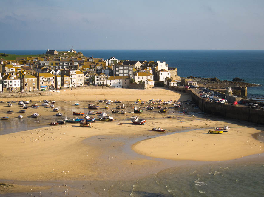
The first picture was taken roughly at high tide. This second picture, with boats lying on the harbor’s sand bottom, was taken when the tide was about half out.
Subscribe to:
Posts (Atom)


 Posts
Posts

